 Click to see larger pictures |
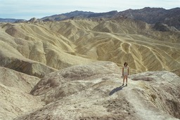
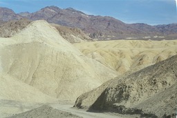
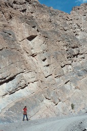
Zabriskie Point
Made famous by Antonioni's film with the same name (1970) Zabriskie Point offers some beautiful views of the Golden Canyon badlands. The yellow and beige colored hills were once lake bottom sediments. The point is named after Christian Zabriskie, an important figure in Death Valley borax mining.
 Click to see larger pictures |
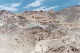
Artist's Drive
This is a one-way nine miles scenic drive through hills splashed with colors from mineral deposits. There are reds, yelows and pinks from the iron salts, green from decomposing mica, and purples from manganese. About halfway through the drive is Artist's Palette a remarkable spot which is worth a stop.
 Click to see larger pictures |
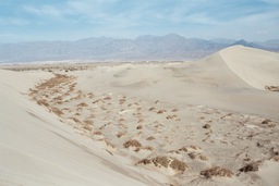
Stovepipe Wells Sand Dunes
Located very close to Stovepipe Wells are the undulating sand dunes. They are being continually recreated by the winds which carry sand from the mountains and then deposit it here. The dunes can be explored by foot (park on the side of the road). There is no trail, but that is part of the fun, you can create your own trail.
 Click to see larger pictures |
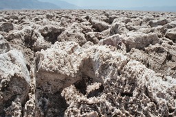
Devil's Golf Course
A field of salt pinnacles today, this used to be a lake more than 2000 years ago. When the lake evaporated, it left behind the layers of crystallized salt. This is constantly recreated as salty water is brough to the surface through capilary actions and then it evaporates resulting in new salt crystals. You can hear the noises made by the salt as it expands and contracts with the changes in temperature.
 Click to see larger pictures |
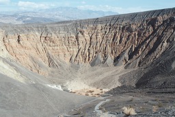
Ubehebe Crater
The Ubehebe Crater is situated in the north of the Valley and it's quite a drive to get there. But if you plan to see Scotty's Castle then Ubehebe is only 8 miles away from the castle. The crater was formed by a massive vulcanic steam explosion a few thousand years ago. There is a trail to the bottom of the cone.
 Click to see larger pictures |
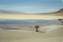
Badwater
Badwater is the lowest point in the western hemisphere, 282 ft (85m) below sea level. This place is also very very hot. There's a small pool of water which surprisingly hosts life (if we were to believe the signs that mark the spot). Turn around and look up the rocky wall to find the sign that marks the sea level.
 Click to see larger pictures |
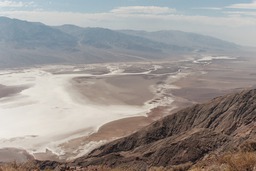
Dante's View
Dante's View is situated at 5475 ft (1650m) on a peak of the Armagosa Range. It offers a spectacular view of the Valley below surrounded by ranges of mountains. This is where you experience the "big picture" of Death Valley. Pools of Badwater lie below; across the valley is the Panamint Range, with its highest point Telescope Peak.
 Click to see larger pictures |
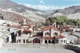
Scotty's Castle
Frankly this is the only thing in Death Valley that I didn't care about. In my opinion it's just a house albeit a fancy one in the middle of the desert. They were charging $10 to visit the interior and we decided it's not worth it. There was a long line of people willing to pay the $10 so in fact it was $10 plus waiting. We visited the grounds instead. The story about the castle goes like this: Scotty was a guy who pretended to have found a gold mine and be filthy rich; in reality he had no money but he persuaded his friend Albert Johnson, a Chicago millionaire who was searching for a quiet retreat, to build this house. The building started in the 20's but was never finished.
 Click to see larger pictures |
Twenty Mule Team Canyon
Close to Zabriskie Point, on the way to Dante's View is the Twenty Mule Team Canyon. A one-way unpaved 2.9 miles road runs through the canyon, allowing one to enjoy the undulating muddy hills visible from Zabriskie Point. These hills where once high in borax which was mined in the early 20C.
 Click to see larger pictures |
Natural Bridge
Natural Bridge is on a short hike (about half a mile) from the parking lot, 2 miles north of Badwater and about 13 miles south of Furnace Creek. You can continue the hike through the narrow canyon for another half mile until you reach the end of if. As with any other hike in Death Valley, bring water, bring water, bring water along.
 Click to see larger pictures |
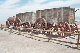
Harmony Borax Mines
These are the remains of a borax-processing plant and a 20-mule-team borax wagon. Laborares used to mine the borax off the ground and then carry it to the plant for processing. The wagon was used to carry the borax concentrate to the Mojave railroad station during a three week round trip. The plant was only used for a few years at the end of the 19th century.
 Click to see larger pictures |
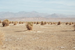
Devil's Cornfield
Devil's Cornfield is located close to the Stovepipe Wells' Sand Dunes area along Route 190. It's a field covered with isolated clumps of the arrowweed plant separated by stretches of empty sand. They resemble shocks of corn in a harvest field, hence the name of the place. The saline soil of the Death Valley floor creates a harsh environment, but even here you can find plants or rather salt loving plants like the arrowweed which thrive in this place.
 Click to see larger pictures |
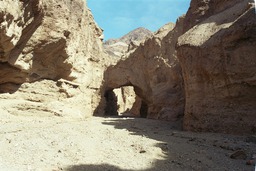
Titus Canyon
The one-way dirt road that goes through Titus Canyon starts at Hwy. 374 in the Nevada desert. The road is 28 miles long and is suitable only for four-wheel-drive vehicles or vehicles with high clearance. Do follow this indication, the road is in really bad shape and you can damage your car (not talking about getting stuck there and blocking everyone that comes behind you). It's one of the most spectacular drives in the park, with gorgeous narrows, twisted rock formations, indian petroglyphs and an interesting geology. Near the beginning of Titus Canyon lies the ghost town of Leadfield which experienced a short mining boom of about 6 months in 1925.
 Click to see larger pictures |