 Click to see larger pictures |
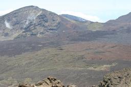
Leleiwi Overlook
On the way to the summit of Haleakala there is an overlook that should not be, well, overlooked :) Here you'll get a different view of the crater than the one from the summit. A short trail starts from the parking lot just beyond mile marker 17 on Highway 378. The crater has different colors here, or that was my impression. In fact the sunlight and swirling clouds keep changing the hues and patterns. Now, if you're lucky (we weren't that lucky) you might encounter a strange phenomenon. Sometimes in late afternoon when the clouds are low inside the crater and the sun is right behind you, usually around sunset, you'll be able to see the reflection of your own shadow on the clouds, ringed with a rainbow. The native Hawaiians have likened the experience to seeing one's soul.
 Click to see larger pictures |
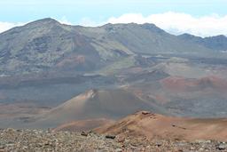
View from the summit (Pu'u 'Ula'ula)
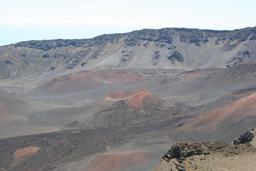
This must be one of world's most amazing views. The view of the crater will take you breath away. Streaks of red, yellow, gray and black trace the courses of recent and ancient lava, ash, and cinder flows. I imagine this is how Mars looks like. I took about 100 pictures of the crater, I just couldn't stop. Haleakala's summit elevation is 10,023 feet (3055 meters), but it's believed that once it was much higher than this. Hawaiian volcanoes gradually sink into the ocean because their weight slowly bends down the Earth's crust beneath them.
 Click to see larger pictures |
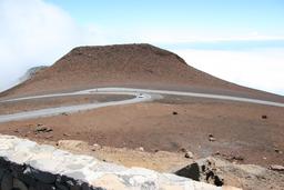
Magnetic Peak
Southeast of the summit of Haleakala is the Magnetic Peak, Maui's second highest point with an elevation of 10,008 ft (3,050 m). This is a peak that can play tricks on people who try to get oriented :) The iron-rich cinder cone that is Magnetic Peak had a magnetic field strong enough to mess with your compass.
 Click to see larger pictures |
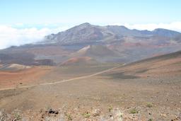
Sliding Sands Trail
The Sliding Sands trail begins at the visitor center near the summit of Haleakala. It's the main trail into the crater descending 2400 feet over a distance of approximately 5 miles. The trail offers a closer view of the cinder cones and the lava flows and you don't need to go its entire distance to find some of the most amazing views. We didn't go the entire distance, because of lack of time, but we still enjoyed it. The colours are out of this world. The trail is in good condition, sandy, but good to walk. Remember that a good rule is that it will take you twice the time to hike back than it took you to descend and that hiking at this high altitude might slow you down even more. The return ascent is steep and hard going. The trail joins the Halemau'u Trail a mile west of Paliku Cabin. You can exit via Halemau'u Trail or loop around by way of other connecting trails and exit the way you came.
 Click to see larger pictures |
Kalahaku Overlook
This outlook accesible on the way down from the summit, provides another spectacular view of the crater floor dotted with cinder cones painted in red, brown and gray. From this distance the cinder cones seem small but can be as tall as 600 feet. The cinder cones are considered to be geologically young, having formed in the last 2500 years. Downslope from the overlook's parking lot is an area covered with many silverswords. Beware, there's lots of bees in this area.
 Click to see larger pictures |
The Silverswords
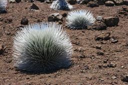
The Haleakala silversword is endemic to Haleakala National Park growing at high elevation inside the crater and along the slopes of the volcano. It is the most famous member of the endemic Hawaiian silversword. It's considered a first class example of adaptation, having managed to live in such a harsh environment as Haleakala. Their silver hairs allow them to retain water and protect themselves from the intense sun at this altitude. The silversword flowers only once during its life and then it dies. Their Hawaiian name is 'ahinahina which means "gray gray". The silverwords were near extinction in the 1920's because of human vandalism and due to the introduced wild goats. Today they are protected and with the wild goats being eliminated from Haleakala, the silverswords have rebounded. There are several trails that highlight silverswords and there's a few of them located near the summit's shelter.
 Click to see larger pictures |
Haleakala birds
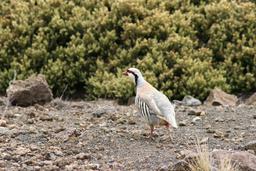
Haleakala is a worldwide destination for bird enthusiasts, being noted for its unique birdlife. Due to its relative isolation for a long period of time, Hawaii was an ideal ground for the development of unique native life. Very famous is the nene, the only remaining species of Hawaiian goose. However, most of the birds you'll see in the park are introduced species like pheasants, chukars, skylarks, mockingbirds. For example we've seen many chukars on the park roads.
 Click to see larger pictures |
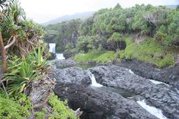
Kipahulu
The Kipahulu area of Haleakala National Park is lush and green and full of waterfalls in total contrast to the red and gray bare lands of the Haleakala crater. To get there you'll have to drive the highway to Hana, a narrow, twisting, full of hairpin turns and one lane bridges road. At Kipahulu you can hike and swim in the pools (when the streams are low). From the Kipahulu Ranger Station, trails lead upstream through the rainforest to larger waterfalls and spectacular overlooks of the coastline. Kipahulu has a long history of human habitation. Many historic and archeological sites are visible from the trails in Kipahulu.
 Click to see larger pictures |
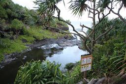
'Ohe'o Gulch aka Seven Sacred Pools
'Ohe'o Gulch is located in the Kipahulu part of Haleakala National Park. For many years this place was called "The Seven Sacred Pools" a name that was actually a marketing gimmick intended to attract tourists to the area (the pools are not sacred and there aren't seven of them). It a series of lovely waterfalls and swimmable pools that cascade until reaching the ocean at the volcano's base. The flow of water made its way through volcanic rock and the rainforest engulfs the place with lush vegetation. It's a very lovely spot. When we visited the pools were close to swimming due to floods. The 'Ohe'o Gulch is located at the end of the highway to Hana, a narrow, twisting, full of hairpin turns and one lane bridges road. There is also a campground just on the other side of the 'Ohe'o Gulch parking lot.
 Click to see larger pictures |
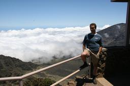
Above the clouds
As you drive up to the summit the road passes through a bank of clouds and then emerges above the clouds. The view from above the clouds is simply a impressive sight giving one a feeling of being on top of the world. The summit also usually rises above these clouds giving you a clear view of the crater floor. This is the reason so many people come here to watch the sunrise or the sunset. The attraction of the sunrise on the volcano for which people get up at 3 am (so they have time to get to the top), is that you are above the clouds and the effects of the sunrise above the clouds is spectacular.
 Click to see larger pictures |
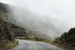
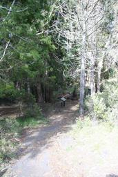
The long and winding road
The first part of the journey is the drive to the volcano itself, a twisty, 30 miles trip through ranchland. This drive through upcountry Maui to Haleakala is a great roadtrip experience. The road climbs quickly, a total altitude gain of 10000 feet (3000 meters) and soon you'll find yourself above the clouds, looking down on fields and beaches. The road to the top travels through numerous climates, which are surprisingly sharply defined: open forest, grasslands, desert, and seemingly barren volcanic ground. You will see numerous signs telling motorists to watch out for cyclists, which use this road to come down from the summit. After you passed the park entrance you'll see signs advising you to watch for Nene birds crossing the road.
 Click to see larger pictures |
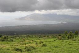
View of the island
During the drive through upcountry Maui to Haleakala from place to place the clouds will part and you'll be able to see the south Maui shoreline from the highway. It's a beautiful sight, worth stopping for a better look. Just make sure you pull over where you have enough space not to block the highway.
 Click to see larger pictures |