 Click to see larger pictures |
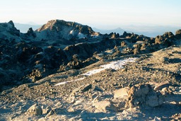
Lassen Peak
Lassen Peak is a dome volcano, the southernmost in the Cascade range. Together with Mount Shasta which lies to the north, Lassen Peak (also known as Mount Lassen) shapes the skyline of inland Northern California. It has last erupted in 1914-1915 followed by some minor volcanic activity in 1921. It was officially declared asleep in 1921.The trail to the top is 5 miles round trip but despite the short distance the elevation gain of about 2000 feet makes this hike to be rated as moderate to strenous in difficulty. The trail starts from the park road (there is a parking lot at the start of the trail). At first the path winds through wooded area but pretty quick the vegetation is gone and you're left to enduring the strong winds blowing from the west. It's a good idea to bring a jacket. The trail is quite popular when conditions allow. A round trip takes between 2 and 4 hours.
 Click to see larger pictures |
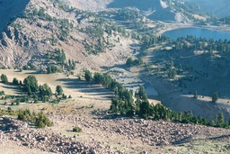
View from Lassen Peak
This picture wasn't taken from the Lassen Peak's summit but from the trail to the summit. It shows the park road (and the parking lot at the head of the trail) and one of the many lakes of Lassen National Park. Once you reach the summit you can hike around it and see the remains of the last eruption of Lassen Peak, which took place in 1914. Much of the chunky rocks at the top were pushed out at the time of the eruption. By hiking around the summit you can also enjoy nice views of the park and of the mountain ranges that surround the park. But don't forget to bring a jacket, it's very windy at the top.
 Click to see larger pictures |
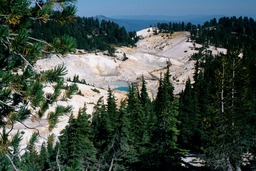
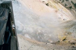
Bumpass Hell Trail
Seeing a picture of Bumpass Hell was what made me decide to come to Lassen in the first place (unfortunately my picture didn't come out that well, but that's because I followed the instructions and kept to the path; the earth is hot and steaming around there). Bumpass Hell is the largest area containing geothermal features in Lassen Volcanic National Park. It takes its name from an unfortunate gentleman who discovered the place and lost a leg there by falling into a hot mudpot.The trail to Bumpass Hell is quite easy. It's 3 miles round trip and it doesn't change much in elevation. It's closed in the winter due to snow and even in the summer some patches of snow remain. The active area can be seen from some distance away. The sulphury smell will also attack before you reach the boardwalk that takes you close to the thermal area. Keep to the boardwalk and take some time exploring the steaming fumaroles and mudpots. The blue color of the springs makes for some beautiful photos.
 Click to see larger pictures |
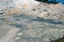
Bumpass Hell Mudpots
The image shows a closer shot of the Bumpass Hell mudpots. The hydrotermal activity is the result of water getting far underground to a chamber of hot magma, where it gets heated up, and then coming back to the surface. This process results into bubbling mudpots, steaming fumaroles and boiling springs. There is a boardwalk going around Bumpass Hell. For your safety it is advised that you keep to the boardwalk.
 Click to see larger pictures |
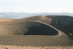
Cinder Cone
The Cinder Cone in Lassen Volcanic National Park is a 700-foot-high volcanic cone. Now dormant, the cone was formed in two eruptions of ash and volcanic cinders in the 1650s, as indicated by recent geologic studies of the volcano. The cone was built to a height of 800 feet above the surrounding area and spread ash over 30 square miles around it. The black and charred-looking Cinder Cone is bare of any sort of life and together with the surrounding lava flows and ash deposits make for an interesting sight, a lesson about how volcanic activity can change an area.
 Click to see larger pictures |
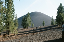
Cinder Cone Trail
The Cinder Cone Trail is another worthy hike at Lassen. The trail is 4 miles long and starts from the Butte Lake Campground located at the far northeast corner of the park. To get there we had to drive out of the park and back in on a dirt road. The first 2 miles of the hike are flat, going through forest area but the last half mile includes an fairly steep 800 feet ascension of the cone itself. This last half mile is not the most pleasant part of the hike, since the cone is made of pure gravel and you'll be making one step forward followed by two involuntary steps back. But seeing the bare volcanic landscape is worth the effort.
 Click to see larger pictures |
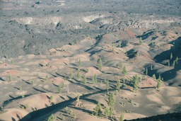
Painted Dunes
The Painted Dunes can be seen from the top of the Cinder Cone. The pastel colors are very beautiful (my pictures doesn't show them at their best as it was taken at a very sunny moment of the day). The colors are formed by oxidation of the cinder rocks and ash that fell from volcanic eruptions. Unfortunately the Painted Dunes are off limits to hikers but you can admire them from far away.
 Click to see larger pictures |
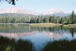
Manzanita Lake
Manzanita Lake is located close to the NW entrance of the park. It's a nice place to rest by the water, or to take a leasurely stroll around the lake for some great views of Lassen peak (like the one in the picture which shows the lake with Lassen Peak in the background). Manzanita lake is surrounded by willows, mountain alders and many other types of trees which I couldn't recognize. When we took our stroll we ran into a herd of deer; there were about ten of them. In addition to the visual delights Manzanita Lake provides good fishing. One of the Lassen campgrounds is located here.
 Click to see larger pictures |
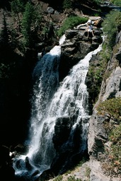
Kings Creek Falls
The get to the Kings Creek Falls one has to hike the three miles round-trip trail which starts from the main road at the Kings Creek parking area. The trail goes through the forest and becomes parallel to the Kings Creek very early in the hike. You'll encounter a series of small cascades which end with the 50 feet high Kings Creek Fall.
 Click to see larger pictures |