 Click to see larger pictures |
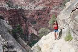
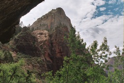
Hidden Canyon Trail
This very steep hike is not for anyone fearful of heights. The trail starts at the Weeping Rock parking area and ends at the entrance of a narrow canyon, a 2.2 miles (3.54 km)round trip. You can continue your way through the canyon after that; about 0.5 miles (0.8 km) farther you'll find a natural arch. You can still continue 0.6 miles from here. We stopped when we got tired of climbing big boulders. The portion of the trail up to the canyon climbs for 850 feet/259 m. In the beginning the trail is wide but towards the end of it there is a brief portion where the trail is narrow and cut into the cliff side, with long drop-offs. You'll need to make use of the chains hanging from the rock. This hike is a steep uphill climb so I would say it falls under the "strenuous" category. The trail up to the canyon is in full sun, hot for hiking in the mid-days of summer, so bring water. Once into the canyon it is shady and cool and very pleasant.
 Click to see larger pictures |
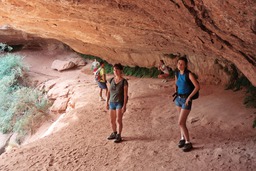
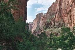
Canyon Overlook
Canyon Overlook Trail is a short hike which takes you to a fine viewpoint of lower Zion Canyon, 1000 feet (304m) below. The trail begins from across the parking area located at the east end of the Zion-Mt. Carmel Tunnel. If you're coming from the west (from the Zion Canyon) turn right into the parking lot immediately after emerging from the tunnel (and of course, if you're coming from the east, turn left into the parking lot right before the tunnel). The trail starts from across the parking lot. It's an easy and pleasant hike of 1 mile (1.6 km) round trip of moderate difficulty. I remember the hike to be a lot of fun, we passed through an overhanging cave and saw some interesting rock formations along the way. But the true reward comes at the end of the trail, the gorgeous view of canyon.
 Click to see larger pictures |
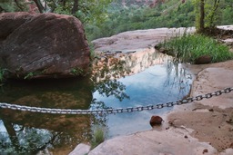
Emerald Pools Trail
Emerald Pools is one of the most popular hikes in Zion. It is probably easy to moderate in difficulty, depending on your ability. There are three pools, the lower, the middle, and the upper pool (great naming there). Departing from the Zion Lodge we crossed the street and headed over the bridge to find the trailhead. The first 0.6 miles portion, up to the lower pool is paved (and very crowded). Waterfalls cascade into the lower pool from the middle pool, and the trail passes under the rock overhang behind the falls. In August the falls were just a trickle, but it was still fun to see them. Continuing the next 1 mile and 150 foot ascent you'll find the middle pool which is a lot smaller. At its turn the middle pool is fed by a stream from the upper pool. From the middle pool there is another 0.5 mile and 200 foot ascent to the upper pool most of it on sandy and rocky ground. The upper pool sits between a small beach on one side and a sheer cliff on the other. It's a beautiful trail, very green because of the moss and ferns and all the vegetation which feds on the flow of water. You can return to Zion Lodge on a different trail. The picture shows the middle pool (or what was left of it in August).
 Click to see larger pictures |
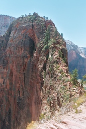
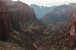
Angels Landing Trail
This is another hike not recommended for anyone with a fear of heights. You will gain 1500 feet in elevation along this 2.5 miles hike and will ascend the steep switchbacks of Walter's Wiggles. There are beautiful views along the way. Again, you start on the valley floor by crossing the Virgin River on a big footbridge. Although very steep, the first part of the trail, which follows a wide man made trail (mostly paved to keep erosion in check) for about 2 miles, was not to hard to deal with. We started the hike in midday and it was really hot. The views along the way were excellent.Even though we were prepared for 1500 feet attitude gain in 2.5 miles we were not prepared for what came after the first 2 miles. We figured it's another half mile, how long can it take, maybe 15 or 20 minutes of hiking. And why is this hike so famous, there was nothing special up to this point. Beautiful views, ok, but you can see that everywhere in Zion. And then we noticed that the nice wide trail came to a stop and from now on our hike will be on a steep and narrow rocky ridge. We lost two people in our group who decided they won't try this part and they'll wait for us at the 2 miles mark. But the good part was that the park service has been there ahead of us and put up chains which were very useful during the climb. What complicated matters even more was the two way traffic, people going up and coming down. At the top you'll find the most amazing view of all, the Zion Canyon at your feet. Along the way it looks like there are plenty of hikers on this trail but when we reached the summit we were the only ones there and it was the same way for almost half an hour.
 Click to see larger pictures |
Weeping Rock
Weeping Rock is probably the shortest trail in the park, only half mile round trip. It seems to be very popular (due to its short distance I guess), we saw crowds of people walking back and forth. It's a somewhat steep hike but it's over so fast that anyone can do it. The trail ends at a rock alcove where springs drip from overhead creating a lush area of greenery which grows from the thin cracks and crevices of the seeping walls. The alcove offers a spectacular view of the Zion Canyon.
 Click to see larger pictures |
Riverside Walk
Riverside Walk is probably the easiest and most popular trail in Zion NP. The walk is a 2 mile round trip on paved ground with little change in elevation. It begins at the farthest end of Zion Canyon, the last stop of the shuttle. The trail follows the Virgin River upstream from the Temple of Sinawava offering beautiful views of the river trapped between the canyon's red sandstone walls. The path ends where the renowned Zion Narrows trail begins. When we were there the trail was full of begging squirrels.
 Click to see larger pictures |
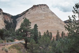
Zion Mt. Carmel Hwy
The Zion Mt. Carmel Hwy (UT 9) is a gorgeous scenic drive with beautiful views of the Zion Canyon and the red-colored sandstone of the surrounding peaks. Enjoying the fine views comes with a price, the road is steep and narrow with hairpin switchbacks and a surprise in the form of a narrow tunnel. The tunnel is so narrow that escorts must accompany oversized vehicles. There is no light in the tunnel, which is 1 mile long, but there are windows cut into stone which allow views of the peaks outside (just make sure the driver isn't watching). The tunnel was carved through the stone in the early 1900's when the technology available for such projects was in its infancy. There are turn-offs along the highway, where you can stop and enjoy the views (no stopping in the tunnel, though).
 Click to see larger pictures |